

Start Here
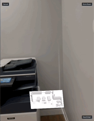
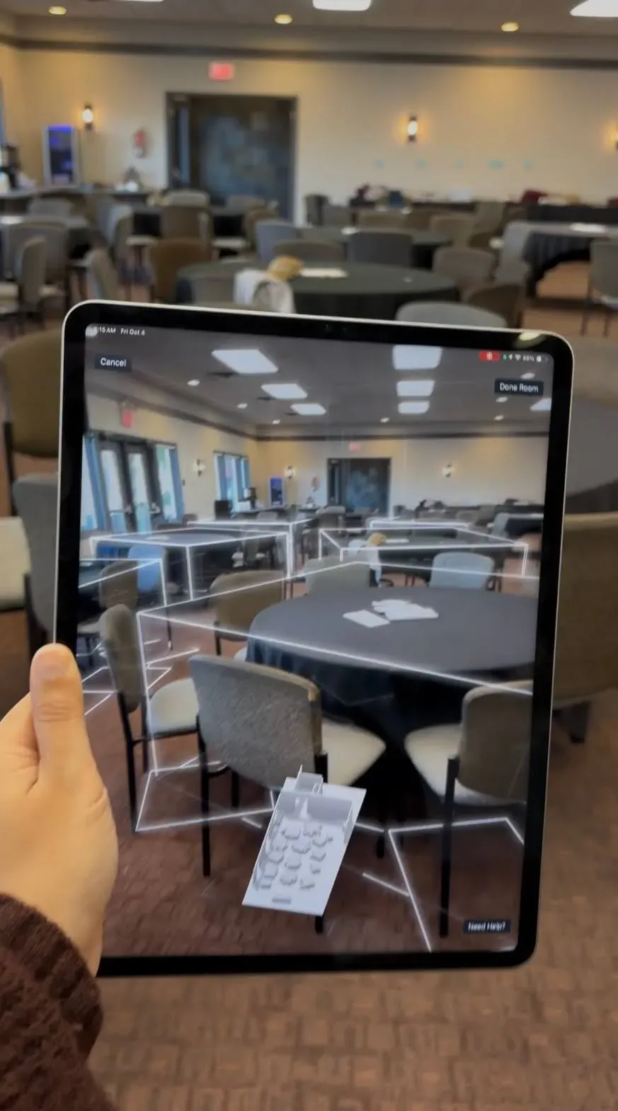
The Mappedin Scan iOS app enables LiDAR scanning with iPhone Pro and iPad Pro devices to create accurate digital floor plans and 3D indoor maps without existing blueprints. The app automatically captures furniture, objects, and precise measurements of indoor spaces. Users scan spaces, upload to a Mappedin workspace, and continue editing on desktop to add rich information, safety annotations, wayfinding, and publish interactive maps with QR codes and shareable links.
Don’t have access to a floor plan for your space? Or perhaps your floor plan is outdated and you need a new one? Don’t worry! You can easily capture your space and create digital floor plans with the Mappedin iOS app if you have an Apple iPhone Pro or iPad Pro.
With our app, begin your indoor mapping journey with a LiDAR scan instead of starting with a traditional floor plan. Scanning your space produces a floor plan that can be directly uploaded to your Mappedin workspace. From there, you can continue to edit your map from your desktop, add rich information to it, and publish the map for others to use.
Reasons to start mapping with the Mappedin iOS app
You have full access to the building you want to map
If you have unrestricted access to the building you wish to map, the Mappedin iOS app is ideal to start mapping with. The app allows you to walk through your space and capture spaces in detail quickly.
You don't have access to building floor plans
Sometimes, floor plans are unavailable, especially for older buildings or newly constructed spaces. The Mappedin iOS app unblocks this issue by allowing you to scan and create a floor plan from scratch. No need to hunt down elusive documents or rely on outdated blueprints.
You want accurate measurements of your building
Precision is key in indoor mapping, and the app delivers just that using LiDAR technology to capture highly accurate measurements. This level of detail is crucial for both navigation and planning purposes.
You want furniture in your space to be part of your map
Without doing additional mapping work, the app can capture objects in your space. The app does the heavy lifting for you when scanning objects such as chairs, desks, tables, couches, and more. Furniture is represented in our platform as objects and is taken into consideration when maps are viewed in 3D and navigation routes are generated.
Examples of spaces you can capture
Capturing your Airbnb property
As an Airbnb host, providing guests with an interactive 3D map of your property enhances their pre-travel planning experience. By capturing your space with the Mappedin iOS app, you can quickly create a floor plan and add more information to your property map to highlight unique features. Whether it’s a cozy reading nook, a sitting area in your garden, or a chef’s kitchen, an interactive map can showcase these areas effectively. It may also help set expectations and ensure guests are fully aware of your property amenities.
Mapping a venue for an event
Hosting an event and need to provide a map to attendees? By capturing the event space, you can map a layout suitable for creating a seating plan and highlight amenities such as catering areas, stages, dance floors, and bars. Your team and guests can use the map to discover everything your event offers.
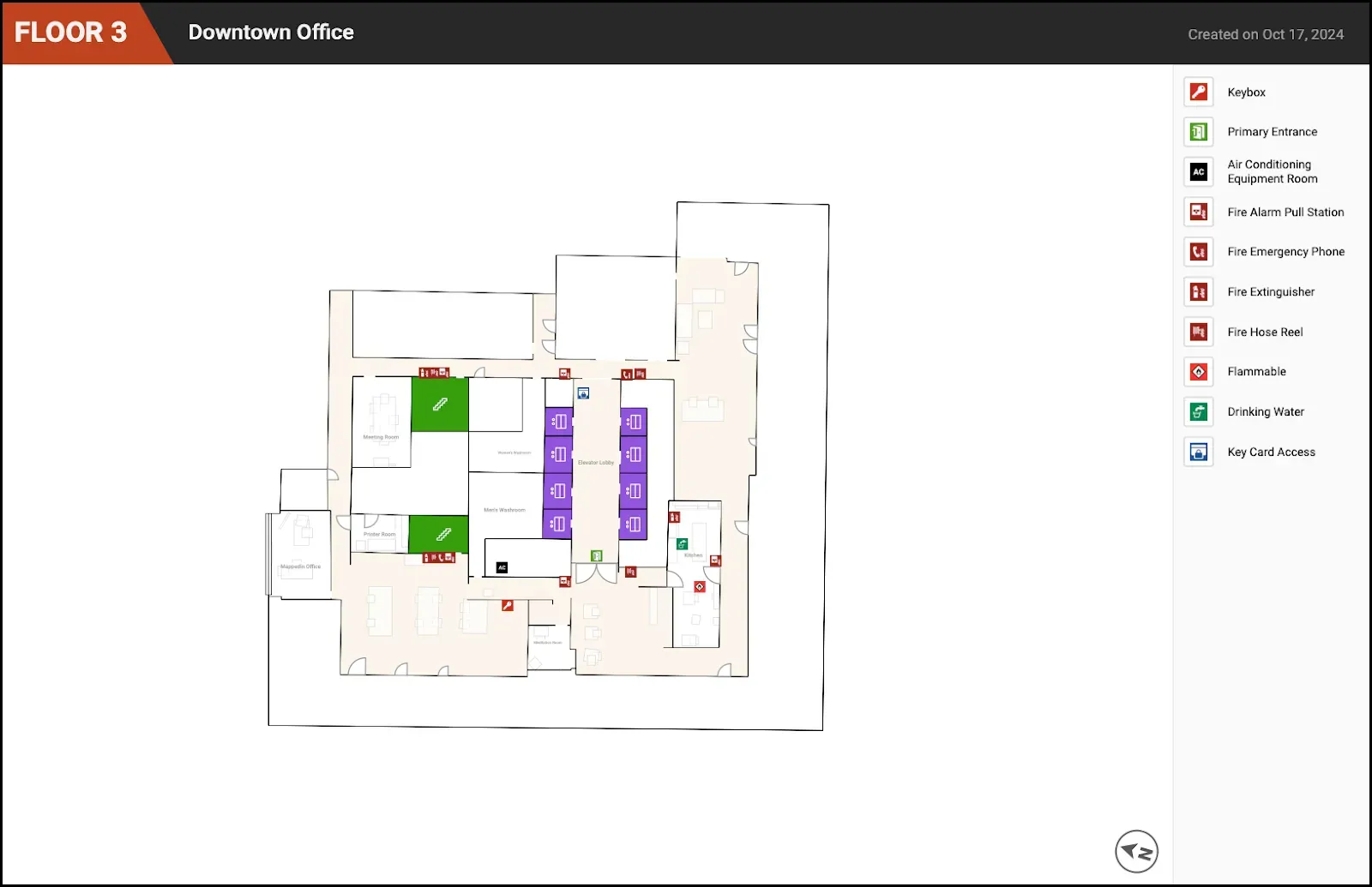
Making detailed layouts of your workplace for safety
Safety is paramount in any workplace. Having a detailed workplace map is crucial for emergency planning and day-to-day operations. Indoor maps can include important safety information such as fire exits, first aid stations, fire extinguishers, and emergency equipment access. Sharing this with your team, building management, and local fire departments ensures that everyone is aware of safety protocols and the layout of an office.
How to capture your space with the Mappedin iOS app
- Download the Mappedin iOS app on Pro and Pro Max iPhone models or the 11-inch and 12.9-inch iPad Pro models from 2020 and later.
- When scanning, move the device around slowly to allow it to capture details such as walls, entrances, and objects.
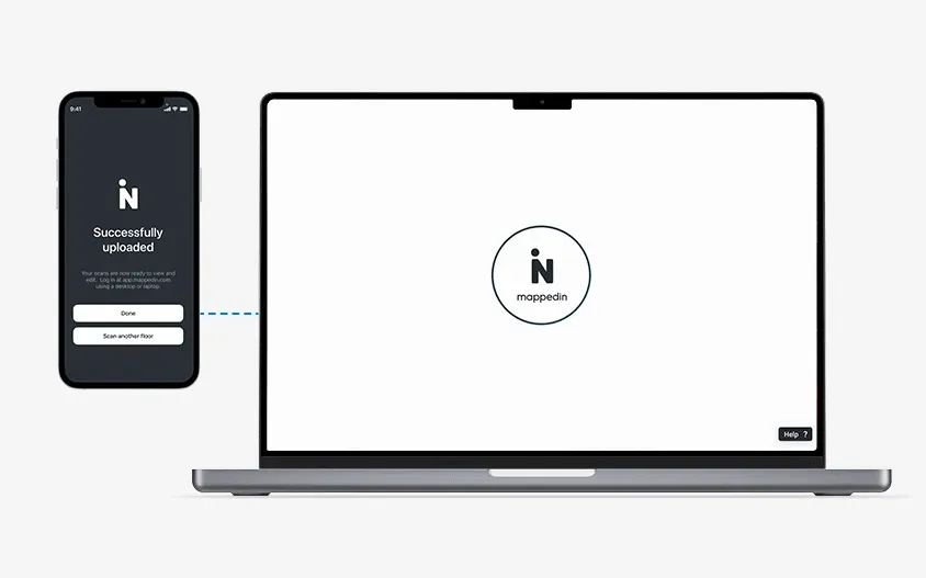
- Once you’re done scanning, you can upload your scan directly to the Mappedin workspace of your choice.
- You also have the option to export the floor plan produced by your scan as a GeoJSON, SVG, PNG, and USDZ.
Some helpful tips about scanning your space:
- Make sure you have a stable network connection so that the correct GPS coordinates are assigned to your building.
- Make sure the space you want to scan has good lighting. A lighting of 50 lux or higher is recommended (lighting you may encounter in a typical living room) to ensure a smooth scan with a clear video stream and good AR tracking performance.
- Try not to exceed 2,000 square feet (186 square meters) per scan. We recommend scanning one room at a time and merging your scans together to form a larger floor plan.
- You can start a scan and return later to finish it. Just make sure you end your scan in the first session and label it clearly.
- If your building consists of multiple levels, you can scan the rest of the levels by clicking on ‘Scan a new floor’ so that your levels are uploaded to the same map in your Mappedin workspace. Remember you have control over which elevation you want the level you scanned to end up on in your map.
- You also have the option to upload your scan to an existing map, but proceed with caution because this will completely overwrite the existing floor.
Continue mapping from your workspace
After you capture your space and have uploaded floor plans to your Mappedin workspace, here are additional tips to help you explore and create a map:
- Go to app.mappedin.com on your desktop or iPad to view the map created from your scanning session.
- Rename the map - it helps you keep your workspace organized
- Update the position of your map if necessary so that it matches the building footprint - to do this, go to Level Selector menu > Address & World position
- Edit map geometry - adjust walls, doors, and more
- Add connections to multi-level maps - this helps with wayfinding between floors
- Add names to rooms, doors, points and objects - the more information you add, the more discoverable your map is
- Add descriptions, links, and images to help visitors find things in your space
- Add safety annotations to your space - create safety maps easily to help visitors and emergency personnel understand where safety equipment and fire exits are located
- Turn on/off map layers in your map preview and create multiple versions of your map
- Update the map theme to a style of your liking
- Publish your map and share it with a QR code or a link

The Mappedin iOS app offers a revolutionary way to create detailed, interactive maps quickly and efficiently with only a mobile device. Whether you lack access to traditional floor plans or need an updated visualization of your space, our app provides an easy way to start capturing and transforming into interactive 3D maps. Embrace indoor mapping with Mappedin’s advanced technology and make the process easier and more accurate than ever before.
To get started for free, simply sign up at app.mappedin.com on a desktop device. Download the Mappedin iOS app from the App Store to your Apple Pro device to start scanning.
Share


