

You’ve recently made a great map with Mappedin…but have you considered all the possibilities for using this map and what you can do with it? This blog will walk you through five map export options available in Mappedin, use cases, and how you can make the most of your indoor maps and data.
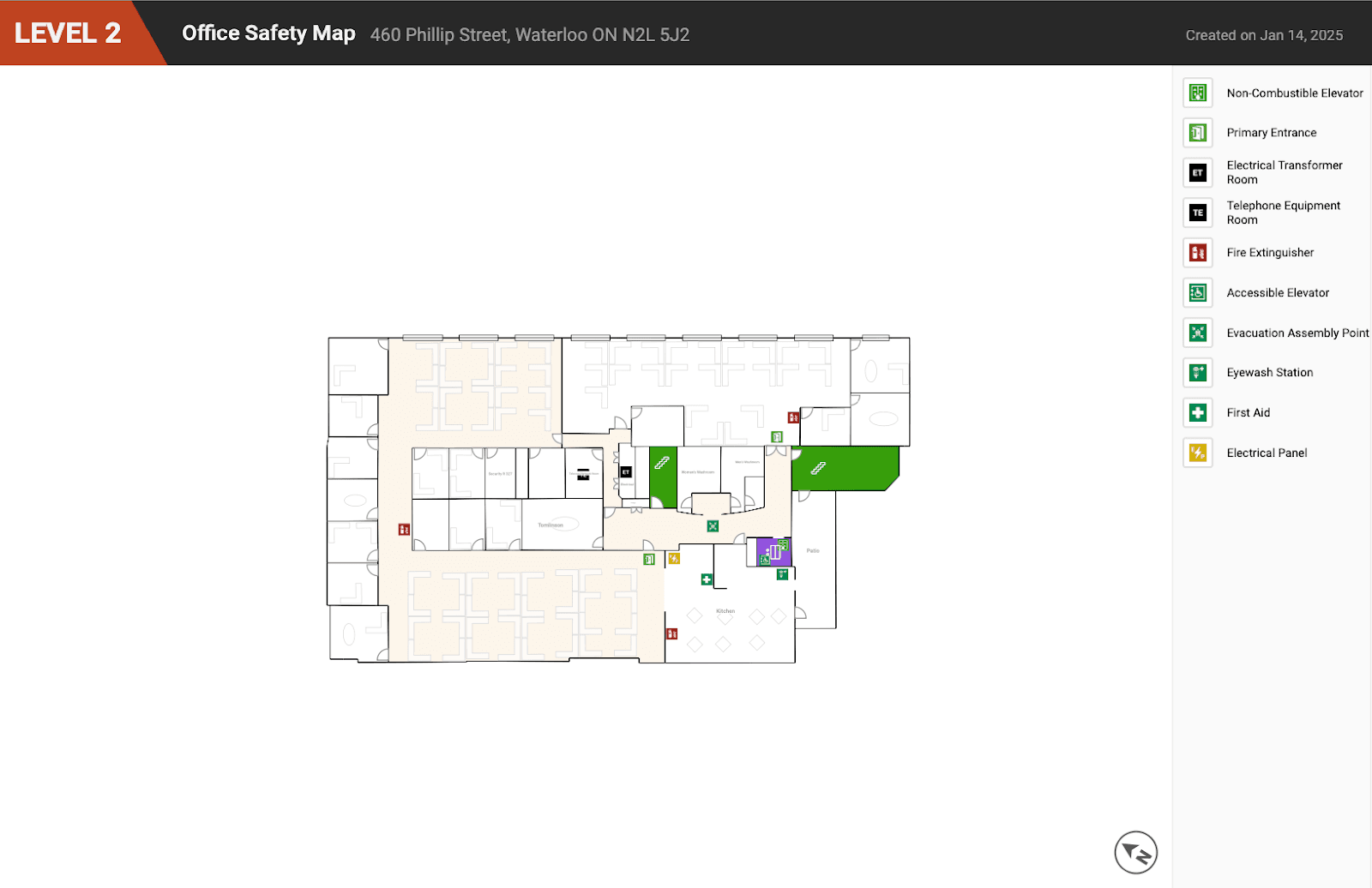
1. Make places safer with a Safety PDF
One of the simplest yet most impactful uses of your Mappedin map is to create a Safety PDF. This print-ready PDF highlights critical safety features of your venue, such as door swing direction, windows, stairs, elevators, room labels, and safety annotations. It has everything needed to be printed and posted in your building, on every floor, and by entrances and emergency exits.
Available on all Mappedin subscription plans including Free, Safety PDF is a very accessible export option for any organization’s safety and emergency preparedness planning. With these safety maps on file, proactively share them with local fire departments during annual inspections or emergencies. These maps are also useful for event planning and security teams who require evacuation plans.
2. Enhance workplace connectivity with Microsoft Places IMDF
Microsoft Places is a workplace management platform that helps teams reserve workspaces and meeting rooms, and locate amenities. Floor plans are a key component in Microsoft Places to understand how spaces are used. Our indoor mapping allows any organization to convert floor plans to Microsoft Places IMDF completely free. Indoor Mapping Data Format (IMDF) is a GeoJSON-based data format that can be exported and used for indoor positioning.
To learn more about how to create indoor maps and export Microsoft Places IMDF, see our most recent guide.

3. Render 3D models from glTF
For those interested in 3D modeling and virtual applications, the Graphics Library Transmission Format (glTF) export is a perfect choice. Available to be exported on a Mappedin Plus subscription, glTF is an ideal format for sharing 3D models between various 3D modeling software applications. Making and exporting maps to glTF can be used for video games, augmented reality (AR) and virtual reality (VR) applications. It also offers flexibility for modelers and developers to create professional, high-quality 3D models, scenes, animation, and other design assets with applications such as Blender. Further, it can help with 3D visualization and analysis in architecture or engineering applications.

4. Increase graphic and web design flexibility with SVG
Mappedin Plus maps can be exported to SVG (Scalable Vector Graphics) format, an XML-based vector image format for two-dimensional graphics. It was designed specifically to work with web technologies, making it the ideal choice for print maps, website graphics, and applications. In the SVG, layers from a Mappedin map are defined as shapes, lines, and curves, meaning the vectors can be scaled to any size without losing quality, making them suitable for responsive design.

SVGs are also ideal for vector animations. Imagine creating a map and using it as a base layer in an animation. Animating moving objects on top of the base layer with the flexibility to move and scale can create high-quality visualizations. While an SVG could be used to create web maps, we recommend the Mappedin viewer as a better option that includes all map navigation elements and controls.
5. Get more out of a Mappedin MVF
Mappedin Venue Format (MVF) is our proprietary indoor mapping 2D format based on the GeoJSON standard and is used to power digital map experiences. This format contains data for walls, floors, and other map elements and information including metadata such as names and descriptions. It also contains nodes and path data used to determine navigation within venues.
Also available through an API for easy data sync, MVF allows seamless integration of your map data into other applications. You can use MVF files to render maps in your custom applications being built with third-party tools such as Deck GL, Mapbox, and Atlas.co. Check out this developer guide and sandbox on how to render MVF with MapKit JS.
While anyone can create indoor maps, some may not require 3D wayfinding. MVF provides the necessary data and gives customers the freedom to build a 2D map experience for their specific use case. This may be useful for operational maps, maintenance maps, or security maps that only require a top-down view.

Key takeaways
- Mappedin maps and data extend well beyond a web map.
- Safety PDFs highlight critical building features such as doors and safety symbols. Print them for each floor and display them for safety preparedness.
- Enable workspace and meeting room booking by exporting maps to IMDF for Microsoft Places.
- Export maps in glTF for 3D modeling and development of video games, AR, and VR applications.
- Offer scalable 2D vector representations in SVG, suitable for graphic design and animations.
- For enterprises looking to integrate maps in other applications, our GeoJSON-based MVF is a comprehensive format that encapsulates raw data including geometry, metadata, and nodes and paths for navigation.
Whether you need a simple safety map, room-booking functionality, rendering 3D models, or integrating data into custom applications, you can unlock a range of possibilities for using Mappedin indoor maps in other ways effectively. As we continue to work with our mapmakers and customers, send us feedback on what other data formats would be useful to you.
To see more use cases and possibilities, dive deeper into our Developer Portal and join discussions on our Developer Community Forum.
Get in touch with our Sales team if you have any questions about our products or Enterprise custom solutions.
Tagged In
Share


